Roatan Weather Forecast
As presented by Radio Roatan, FM 101.1 or www.roatanradio.com
and
CoCoView Resort, www.cocoviewresort.com, 800-282-8932
CoCoView is at 16.3°N Latitude x 86.5°W Longitude
In the
NW Caribbean Sea
Sunday July 17, 2011
Skies will be sunny with mid to high level cloudiness. Today, the winds will be strong from the east at 20 to25 mph. They will increase to 25 to 30 mph, this afternoon and evening. The seas are rough at 4 to 6 feet . Occasionally, winds and seas may be higher. Expect winds and seas to moderate slightly, beginning tomorrow.
Another tropical wave will enter the Western Caribbean later this week. The monsoonal trough is still in place over the mainland of Central America ( See Fig 5 ). The potential for heavy rains and accompanying life threatening, flash floods and mud slides continues. The trough has moved slightly south and west of its previous position.

| Fig 1 - Forecast Wind Speed, Direction & Precipitation_110717 |
 |
| Fig 2 - Forecast Wind Map, 110717_1500LT |
 |
| Fig 3 - Forecast Isobars, Cloud Cover, and Precipitation, 110717_1500LT |
 |
| Fig 4 - Graphicast |
 |
| Fig 5 - Tropical Surface Analysis |
 |
| Fig 6 - Water Vapor, early am_110717 |
 |
| Fig 7 - Caribbean IR Satellite |
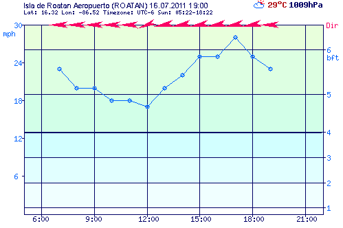 |
| Fig 8 - Wind Speed, yesterday at Roatan Airport_110717_ 1900 LT |
At depth, ocean water temperatures are about 82F to 84F or 28C to 29C . Visibility is generally 60 to 80 feet.
The Tropical Weather Outlook
An area of disturbed weather east of Cape Canaveral, Florida is given a 20% for further development. Elsewhere, tropical storm formation is not expected for the next 24 hours.
The Tides: Moon and Sun
low tide 4:13 am LT Moon Rise –8:10 pm LT
high tide 10:04 am LT Moon Set – 7:26 am LT
low tide 3:56 pm LT Sunrise – 5:24 am LT
high tide 10:52 pm LT Sunset – 6:22 pm LT

No comments:
Post a Comment