Roatan
Weather Forecast
As
presented by Radio Roatan, FM 101.1 or www.roatanradio.com
and
CoCoView
Resort, www.cocoviewresort.com,
800-282-8932
CoCoView
is at 16.4°N Latitude x 86.4°W Longitude
In
the
NW
Caribbean Sea
Friday
September 16, 2011
Today's
weather is essentially a carbon copy of yesterday's. Skies will be
sunny with mid to high level clouds. A weak cold front has entered
the Gulf of Mexico. It is expected to turn stationary later today and
dissipate by tomorrow. As a result of this, the frontal boundary is
now slightly to the south of us. High pressure in the Gulf of Mexico,
will keep this system in place for the next day or so.
 |
| Fig 1 -Water Vapor, Frontal Positions, early am_110916 |
There still is
a slight chance for intermittent rain and thunderstorms, especially
late at night or early in the morning. Winds will be light at 5 mph
to 10 mph from the E to ENE. Seas will be 1 to 3 feet in height.
Expect
these weather conditions to hold through next week.
The
air temperatures will be in the 80s to the mid 90s (F) or 27 to 32
(C). Due to low winds, at times, it may feel like 100 plus degrees.
Everyone, especially, divers should be well hydrated.
At
depth, ocean water temperatures are about 82F to 88F or 28C to 31C .
Visibility is generally 40 to 60 feet.
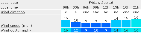
Fig 2 - Today's Wind, Cloud and Rain Forecast
The
Tropical Weather Outlook
Hurricane
Maria
heads for New Foundland.
A
tropical wave located is centered about 360 SE of us. Tropical storm
formation is not expected for the next 24 hours.
 |
| Fig 3 - Today's Graphical Tropical Weather Outlook |
The
Tides: Moon and Sun
low
tide 4:44 am LT Moon Rise – 8:30 pm LT
high
tide 11:58 am LT Moon Set – 8:51 am LT
low
tide 5:01 pm LT Sunrise – 5:36 am LT
high
tide 9:35 pm LT Sunset – 5:48 pm LT

No comments:
Post a Comment