Roatan
Weather Forecast
As
presented by Radio Roatan, FM 101.1 or www.roatanradio.com
and
CoCoView
Resort, www.cocoviewresort.com,
800-282-8932
CoCoView
is at 16.4°N Latitude x 86.4°W Longitude
In
the
NW
Caribbean Sea
Saturday
September 17, 2011
A
tropical wave will pass over us today. Skies will be mostly cloudy
with intermittent rain and thunderstorms. A weakening, stationary
cold front in the Gulf of Mexico is expected to dissipate by tonight.
As a result of this, the frontal boundary is now to the north of us.
High pressure in the Gulf of Mexico, will keep this system in place
for the next day or so. Expect skies to begin clearing, later today
and tomorrow.
 |
| Fig 1 - Water Vapor, early am_110917 |
Winds will be light at 5 mph to 10 mph from the E to
ENE. Seas will be 1 to 3 feet in height.
The
air temperatures will be in the 80s to the mid 90s (F) or 27 to 32
(C). Due to light winds, at times, it may feel like 100 plus degrees.
Everyone, especially, divers should be well hydrated.
At
depth, ocean water temperatures are about 82F to 88F or 28C to 31C .
Visibility is generally 40 to 60 feet.
The
Tropical Weather Outlook
Maria
is a post tropical cyclone
NE of Newfoundland.
A
broad low pressure system located about 400 miles southeast of the
Southern Cape Verde Islands is producing disorganized showers and
thunderstorms. Some slow development of this low is possible during
the next couple of days as it moves westward at 10 to 15 mph. This
system has a medium chance...30 percent...of becoming a tropical
cyclone during the next 48 hours.
Else
where, tropical storm formation is not expected for the next 48
hours.
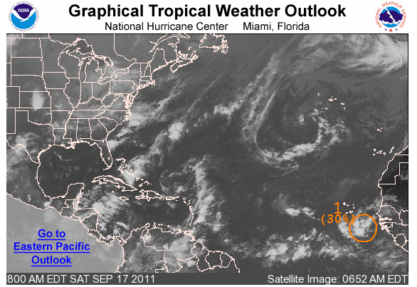 |
| Fig 2 - Today's Graphical Tropical Weather Outlook |
The
Tides: Moon and Sun
low
tide 5:47 am LT Moon Rise – 9:15 pm LT
high
tide 1:39 pm LT Moon Set – 9:41 am LT
low
tide 6:30 pm LT Sunrise – 5:36 am LT
high
tide 10:28 pm LT Sunset – 5:47 pm LT

No comments:
Post a Comment